Category Archives: Shadyside History

St. James Terrace Appears During Shadyside Transition

St. James Place January 19, 1934

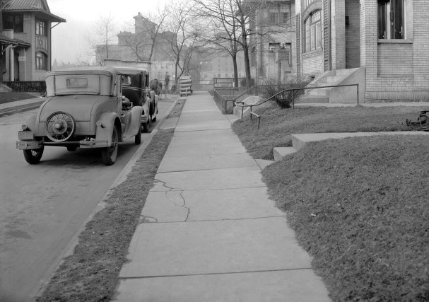
St. James Place January 19, 1934 looking north across the Pennsylvania Railroad tracks to Shadyside Hospital. The buildings in the foreground at right were part of the Jesse C. Stewart Company development. At the time of this photograph the Shadyside Hospital was still a homeopathic facility. Its original building is at left. Straight ahead looking down St. James Place sidewalk and to the right was the newer medical and surgical wing. Image courtesy of Historic Pittsburgh, the Digital Research Library at the University of Pittsburgh.

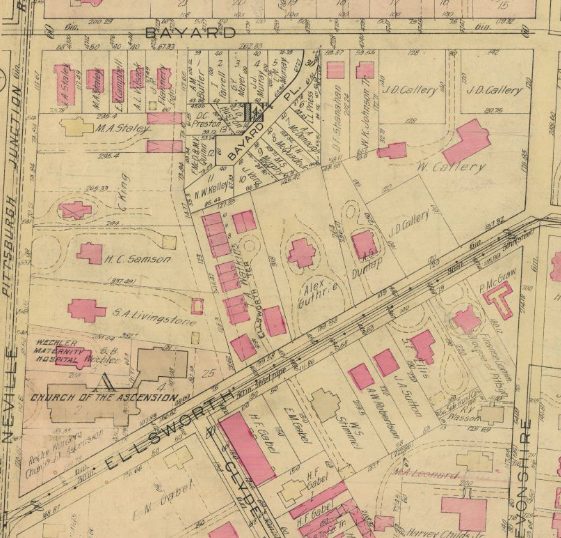
Above is an image of St. James Place in Shadyside from January 19, 1934. St. James Place is a short dead-end road off Ellsworth Avenue, close to and parallel with South Aiken Avenue (see the map below). The two home fronts visible at right in the foreground were part of the Jesse C. Stewart Company property visible in the 1923 map below. In the map, there is a split sidewalk that goes between the two buildings which merges to a single sidewalk through St. James Terrace. The layout remains the same to this day!

Jesse C. Stuart Company in 1923 Shadyside Map

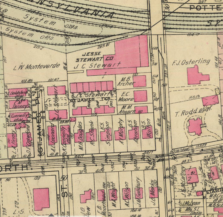
The Jesse C. Stuart Company in Shadyside during 1923. South Aiken Avenue is a through street that runs vertically across the map at right. Ellsworth Avenue runs horizontally across the bottom half of the map. St. James Street connects with Ellsworth Avenue below and to the right of St. James Place. Map courtesy of Historic Pittsburgh, the Digital Research Library at the University of Pittsburgh.

Shadyside Brand Cold Packed Frozen Red Sour Pitted Montmorency Cherries

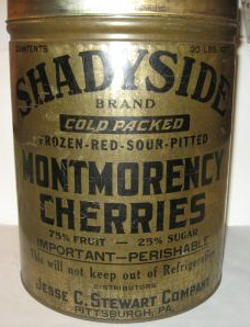
Shadyside brand cold packed frozen red sour pitted Montmorency Cherries from the Jesse C. Stewart Company.

The Jesse C. Stewart Company opened its doors in Shadyside during the 1920s when the neighborhood was going through its most dramatic transition from a suburb to city neighborhood. The company ran a mill and was a supplier of a variety of agricultural products. The image at right shows a can of cherries packed and sold by the Jesse C. Stewart Company.

The row houses along St. James Terrace and the two more substantial houses along St. James Place appear to have been built for employees working in the adjacent large brick building convenient to the Pennsylvania Railroad tracks and South Aiken Avenue. Today the building houses UPMC physician offices. The Jesse C. Stewart Company remained operational at its Shadyside location when the photograph above was taken in 1934.

Horses in Shadyside: Schenley Riding Academy and Bayard Place

Clipping of a 1892 Schenley Riding Academy advertisement. The Bulletin volume 18 clipping courtesy of Historic Pittsburgh, the Digital Research Library at the University of Pittsburgh.

Schenley Riding Academy occupied much of the land at the corner of Neville and Bayard Streets with stables, a riding ring, and other facilities during the nineteenth century. Many of Pittsburgh’s most prominent citizens were members and kept their horses at the academy. In addition, Schenley Riding Academy was a favorite place to rent horses for riding in nearby Schenley Park.

1911 Platt Map, Plate 1 showing a detail of Shadyside. Centre Avenue is along the top edge, Neville Street is along the left edge, and Amberson Avenue is along the right edge. Schenley Riding Academy is the bright yellow patch on the south side of Bayard Street about midway between Neville and Devonshire Streets. The stables take up less land than during the nineteenth century but still exist. Map courtesy of Historic Pittsburgh, the Digital Research Library at the University of Pittsburgh.

The growth of Pittsburgh into and around the suburb of Shadyside along with the rising value of land during the early twentieth century chipped away at the amount of land devoted to Schenley Riding Academy (see the 1911 map above). The horseless carriage ultimately led to its closure and development into Bayard Place (see the 1923 map below). The map doesn’t show houses built yet but the lots around Bayard Place are clearly spoken for!

1923 Platt Map, Plate 1a showing a detail of Shadyside and especially Bayard Place just off Bayard Street (a bit left of center). The homes on Bayard Place were built on top of what was Schenley Riding Academy. Map courtesy of Historic Pittsburgh, the Digital Research Library at the University of Pittsburgh.

Schenley Riding Academy was a hub of Shadyside activity and a core ingredient in the East End social scene for many decades before it closed.

View from Schenley Farms to Shadyside and Beyond, c. 1911

View looking east from Schenley Farms across Shadyside c.1911. Image courtesy of Library of Congress, Prints & Photographs Online Catalog.

The above image has detailed views of early development in the Schenley Farms neighborhood of Oakland and is the leftmost image of a pentaptych (five photograph) view of Pittsburgh’s East End around 1911. I saw it a couple of days ago just after lamenting that I only know of one old image of Wallingford Street in Shadyside (please see my June 16, 2017 post “Wallingford Street and the Hunt for Early Shadyside Images”). It occurred to me that Wallingford Street is somewhere in this photograph.

Please don’t try to zoom in on the above image to see details! The Library of Congress provides online access to a huge very high resolution file (158.4 MB). Too large to post as an image on a webpage. I’ll do some zooming for you below and then I’ll tell you the exact place to get this and the other four images should you like to explore them yourself.

Annotated view looking east from Schenley Farms across Shadyside c.1911. The right arrow points to Bayard Street. The left arrow points to Wallingford Street. Image courtesy of Library of Congress, Prints & Photographs Online Catalog.

First let’s get oriented by pointing out a couple of streets and buildings. Above is an identical image but with two black arrows. The right arrow points to Bayard Street. If you follow Bayard to the large structure standing in Schenley Farms, you’ll find a building just behind this structure and to the right of Bayard. This is the D’Arlington Apartments building (still standing) built during 1909 and 1910 (in a moment you’ll see a close-up). The left arrow points to Wallingford Street. Don’t worry. At this resolution you cannot see the street well but you will when we look at the close-up. Notice the dark shape, almost like the profile of a stuffed chair, to the right of the arrow’s stem. That is Shadyside Hospital. Harder to see are the small dark and then light rectangles at about 2-O-Clock from Shadyside Hospital. The dark rectangle to the left was East End Savings Building (demolished). The white rectangle was the Highland Building (still standing).

View looking east from Schenley Farms c.1911. Image courtesy of Library of Congress, Prints & Photographs Online Catalog.

The image above zooms into the Shadyside neighborhood around Bayard (right) and Wallingford (left) Streets, starting at Neville Street which is hidden behind the buildings parallel with the bottom edge. The D’Arlington Apartments building is at the bottom right corner. Shadyside Hospital, a homeopathic hospital at the time, is more visible as are the East End Savings (darker tower at left) and Highland (white tower at right) Buildings in East Liberty.

View of Wallingford Street from Neville Street to Morewood Avenue. Detail from image courtesy of Library of Congress, Prints & Photographs Online Catalog.

Finally, the above detail focuses on Wallingford Street. Depth is significantly collapsed but I’m able to pick out the individual houses. Can those of you living on Wallingford see your house? Those interested in more detail may download a higher resolution file containing the same image (1.1 MB).

Those wanting to explore further may find the full pentaptych on the Library of Congress webpage Schenley Park and Vicinity, Pittsburgh PA. Please let me know if you have any questions or if you have old photographs to share!